HURRICANE HUNTERS
> Eye-to-Eye
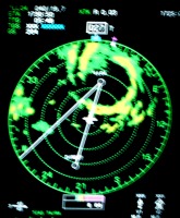 We actually had a week off between Tropical Storm Harvey before we began a
string of five flights into Hurricane Irene in mid-August. This storm made a
feignt toward the Outer Banks, and was the third hurricane of the season.
Fortunately, it stayed out to sea, and threaded between Bermuda and the U.S.
eastern seaboard.
We actually had a week off between Tropical Storm Harvey before we began a
string of five flights into Hurricane Irene in mid-August. This storm made a
feignt toward the Outer Banks, and was the third hurricane of the season.
Fortunately, it stayed out to sea, and threaded between Bermuda and the U.S.
eastern seaboard.