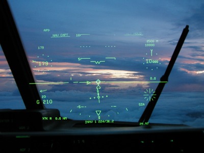
Hop into the copilot's seat for a moment to see what we see (below). One of the improvements in our new J-models is
the "Heads Up Display", a piece of glass onto which flight instruments are projected, in much
the same way as a teleprompter. The pilots can keep their eyes "on the road" while also
seeing the most important information.
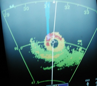
At the time this photo of the radar was taken, the aircraft was 95 nautical miles
southeast of the storm, heading 314 degrees (northwest) towards the eye. Weather officer
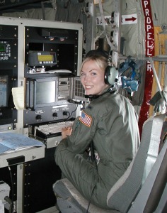
Nicole monitors the radar and sensor readings throughout one long flight in Emily.
Sensors give her updates to temperature, dewpoint, pressure, winds, and location each second.
She can plot these data on her computer, and send text messages to the
National Hurricane Center in addition to automated observations collected every 30 seconds.

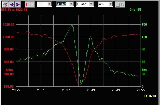
| Here's a screen capture of a plot from the Weather Officer's computer on the evening of July 16th. The
red line is a plot of the sea level pressure on the first pass through the eye, which bottomed out
at 929 millibars. The lime-green line is the plot of the winds, which peaked at 149 knots on the inbound pass
through the northeast eyewall, plummeted to near-zero in the eye, and then picked back up just above 120 knots
in the southwest eyewall. If you click on this picture, you can see a larger version of the plot, and
see just how quickly we passed through the eye... less than five minutes! It gets really busy in
such a small eye: "fix it here", kick out the sonde, and work up the vortex data message for the
National Hurricane Center. Nearly a Cat 5!
|
| 
|
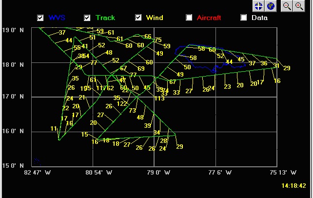
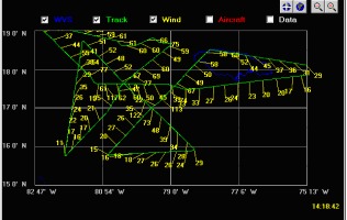
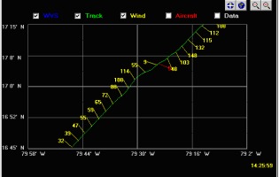
This pair of screen captures depict the winds and airplane's track. The left plot is the
entire mission: four passes through Emily as it moved northwestward to the west of Jamaica (which
is outlined in dark blue). The right graphic is a plot of the winds on the first pass through
the eye, from the upper (northeast) side to the southwest side. The green line is the track of
the aircraft,the yellow barbs point in the direction of the wind (imagine an arrow stuck in a target;
the fletching of the arrow points in the direction from which the arrow flew. In the
same way, these wind barbs are "stuck" in the track, and the other end points in the direction
from which the wind came, and the windspeed is printed (in knots) at the end of the barb.
You can clearly see where the wind shifts direction in the center of the plot (the exact center "fix"
position is plotted in red).
unsolicited plug for another website::
Click this link to exit this site and go to NASA to see a photo taken above Hurricane Emily
from the space station, with the moon rising above the storm.
NASA also has an extensive webpage devoted to hurricane images from
space.
Next to Franklin, Back to Dennis, or Return to Hurricane Hunter Home Page
 Hard on the heels of Dennis was Emily. We followed Hurricane Emily for a full week,
logging more hours and missions on this storm, during its long trek through the
Caribbean and into Mexico. We chalked up 16 missions and 165 hours on this one.
Emily took a more westerly track than Dennis,
and for a time threatened southern Texas. It struck Mexico twice, first striking the Yucatan peninsula as a
Category 4 hurricane, then re-strengthening
to a Cat 3 before it struck northeastern Mexico two and a half days later.
Hard on the heels of Dennis was Emily. We followed Hurricane Emily for a full week,
logging more hours and missions on this storm, during its long trek through the
Caribbean and into Mexico. We chalked up 16 missions and 165 hours on this one.
Emily took a more westerly track than Dennis,
and for a time threatened southern Texas. It struck Mexico twice, first striking the Yucatan peninsula as a
Category 4 hurricane, then re-strengthening
to a Cat 3 before it struck northeastern Mexico two and a half days later.