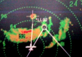
| This picture of the radar shows the aircraft when it was only 22 miles from the eye. The eye is to the southwest of the plane, and the white line shows the track
the plane will fly to get into the eye. But the strong, counterclockwise winds are blowing
the plane sideways towards the right (towards the west). So the plane is "crabbed" into
the wind to use to plane's forward speed to counter this drift, and is actually pointing due south (heading 181 degrees).
This is called a "drift-kill heading", a skill any pilot must be able to do; it is
fascinating to watch as the winds build up and the plane turns more and more at an angle to our
true course.
|
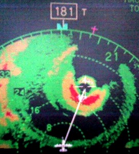
| For the next pass at 0611Z (02:11 a.m.), the Hurricane Hunter crew reported an eye just 2 miles wide,
incredibly tiny, and flight-level winds
of 168 knots (193 mph; winds at the surface are typically lower, due to friction). They extrapolated
the sea-level pressure as 892 millibars, close to a record pressure.
The inner eyewall is the colorful donut in the middle of this picture.
This radar shot shows the tiny eye surrounded by a band of intense rain (red and purple),
surrounded by a rain-free moat (the black ring surrounding the inner eyewall). They had just enough fuel
to make one more pass, and a chance to look for a record pressure.
|
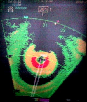
| At 0800Z (4 a.m EDT), they reported a 4 mile eye, and lower pressures yet. The new sea-level pressure
was 884 millibars (26.11 in-Hg), measured by a dropsonde instrument. And realize, this was only
a Cat 1 (80-mph) hurricane just nine hours earlier! The National Hurricane Center discussions
had predicted the storm would intensify, but such "explosive deepening" is still phenomenal to
witness.
|
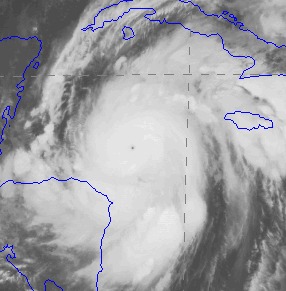
This likely moves the rankings of this years storms as follows: Strongest Atlantic basin hurricane
on record: Wilma (884 mb); Number 4: Rita (897 mb); Number 6: Katrina (902 mb). These are the strengths
of the hurricanes at their peak, not landfall pressures. You can see a list of the strongest
landfalling U.S. hurricanes at NHC website.
I haven't spoken to the crew yet,
but the experience would certainly have been remarkable. With a pressure field so "tight", the
crew would have felt the aircraft descending as they crossed the eyewall into the eye. Looking
at the data from the aircraft, they lost 2680 feet of altitude during the eyewall penetration, in the
five minutes it took to cross the eyewall into the eye. This is expected, and happens because the aircraft autopilot
flies off an altimeter set to "standard" pressures (and this is anything BUT standard); we also have
other altimeters that tell us how high we REALLY are, and using both types of altimeters is how we determine the pressures ("height
of standard surface") at the flight level. In a "standard" atmopshere, the airplane would be at
10,000 feet, but in Wilma, they bottomed out at 6830 feet.
Wilma is also the last name in the hurricane list. This tied the record for the
most named storms in a single season, set in 1933 (before they named storms). If another named storm occurs this year,
they will name the storms according to letters in the Greek alphabet (Alpha, Beta, Gamma, etc.).
If you'd like to learn more about hurricane names, go to the NHC website at
http://www.nhc.noaa.gov/aboutnames.shtml.
Go back to Rita, or return to Hurricane Hunter Home Page